

Mauna Loa: Satellites Capture Incredible Views Of Eruption [Photos]

KEY POINTS
- NASA Earth Observatory shared satellite images over Mauna Loa before and after the eruption
- The satellite views of the eruption show the intensity of the event
- Authorities continue to monitor Mauna Loa's first eruption in decades
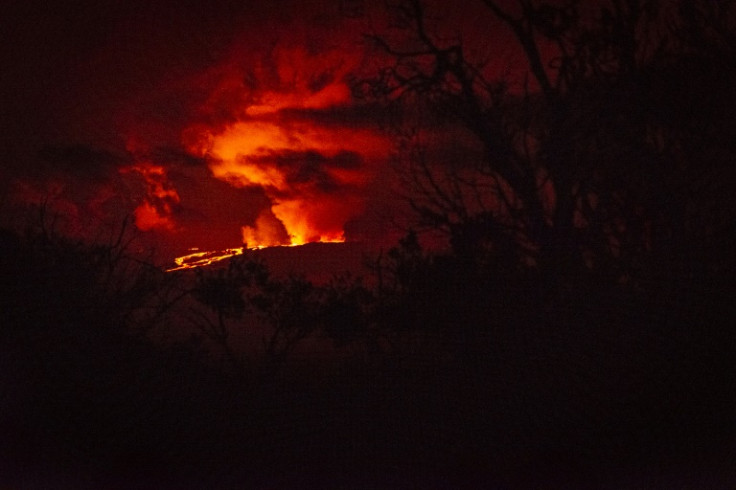
The Mauna Loa volcano in Hawaii has erupted for the first time in decades, and satellites in space have witnessed the event.
The first signs of activity at Mauna Loa were detected in early October, according to NASA Earth Observatory. At the time, the U.S. Geological Survey (USGS) detected increases in small earthquakes, which continued until the eruptions began in late November.
In its Image of the Day for Wednesday, Nov. 30, the agency shared a satellite photo of the Hawaii area, taken using the Visible Infrared Imaging Radiometer Suite (VIIRS) instrument on the Suomi NPP satellite.
In it, one can see the stark difference in the brightness over the Mauna Loa area from Oct. 29, about a month prior to the eruption, and on Nov. 28, when the eruption had already begun.

"It also looks like the lava emitted by the eruption was so bright that the sensor was saturated, producing a 'post-saturation recovery streak' along the VIIRS scan to the southeast," Simon Carn, a volcanologist at Michigan Tech, said, as per NASA Earth Observatory. "These streaks are only seen over very intense sources of visible radiation."
Other satellites have also been capturing incredible views of the eruption, with the GOES-West satellite recording footage of the volcano's intense heat signature.
"This imagery shows the heat signature and the sulfur dioxide released from the volcano's summit caldera, Moku'āweoweo," the National Oceanic and Atmospheric Administration (NOAA) noted in a tweet.
Around 11:30 p.m. HST last night, @NOAA's #GOESWest 🛰️ captured the eruption of Hawaii's #MaunaLoa volcano, inside @Volcanoes_NPS.
— NOAA Satellites (@NOAASatellites) November 28, 2022
This imagery shows the heat signature and the sulfur dioxide released from the #volcano's summit caldera, Moku‘āweoweo. pic.twitter.com/gHEG63rbLb
The European Space Agency's (ESA) Sentinel-2 satellite has also caught a glimpse of the eruption, this time actually getting views of the intense lava flows and thick smoke emanating from the eruption sites.
Sentinel-2 satellite views of Mauna Loa NE rift zone lava flows, which are tightly focused around the source fissures. https://t.co/TZ5O9Z0xaK
— USGS Volcanoes🌋 (@USGSVolcanoes) November 29, 2022
The USGS has also been capturing "spectacular" footage of the eruption, with some even showing the fountains of lava bursting from fissure sites.
Video showing fissures erupting on the Northeast Rift Zone of #MaunaLoa this morning. Fountains of fissure 3 were measured up to 25 m (82 ft) in height. More spectacular photos and videos available on the Mauna Loa website. https://t.co/GoYn4UOT4W #MaunaLoaErupts pic.twitter.com/DTL70XJZuI
— USGS Volcanoes🌋 (@USGSVolcanoes) November 29, 2022
Incredible photos also show rather intimidating views of the lava flow.
These photographs from Saddle Road taken by @alaska_avo David Fee at 6 AM this morning show lava flows moving north-northeast Northeast Rift Zone eruption of Mauna Loa. We will be adding lots more photos to the website today. https://t.co/oSCwzXbW5g #MaunaLoa #MaunaLoaErupts pic.twitter.com/zhINJFe7ud
— USGS Volcanoes🌋 (@USGSVolcanoes) November 29, 2022
Mauna Loa's current eruption is its first one in about 40 years, with the last one being way back in 1984. The eruption lasted for 22 days at the time. Whether the current eruption will follow the volcano's usual trend, however, remains to be seen.
"Mauna Loa eruptions typically last for a few weeks, but this is an evolving eruption and we're just in the early days of it," Ashley Davies, volcanologist at NASA's Jet Propulsion Laboratory, said, as per NASA Earth Observatory.
"The U.S. Geological Survey's Hawaiian Volcano Observatory is closely monitoring and assessing all aspects of the eruption and is a great source of information for people wondering about the risks and hazards this eruption might pose," Davies added.
As of the USGS' Tuesday update, Mauna Loa is on volcano alert level "Warning," which is when a "(h)azardous eruption is imminent, underway, or suspected." So far, Hawaii's civil defense authorities noted that the eruption "does not pose a threat to any communities at this time."
© Copyright IBTimes 2024. All rights reserved.
-
Self-care: Orangutan Seen Apparently Treating Wound
-

European Court Upholds Italy's Claim To Greek Bronze In US Museum
-

Colombian School, A Grim Reminder Of Atrocities Of Rubber Fever
-
More War Debris In Gaza Than Ukraine: UN
-

UK Confirms First Migrants Held For Rwanda Deportation Flights
-
Tesla To Cut Hundreds More Jobs In Musk Cost Push: Report
-

Microsoft Is Turning Into The 'Maestro' Of AI Transformation
-

US-Japan-Philippines Alliance: A Trio With Bitter Past Now Threatens China's Maritime Ambitions
-

Abu Dhabi-backed Group Ends Telegraph Takeover Bid
-
New Post-Brexit Controls: A Thorn For UK Horticulture


