

Mississippi Tornado Track Captured In Satellite Images

KEY POINTS
- The Landsat 9 satellite captured the track of the EF3 tornado that ripped through Mississippi
- The satellite images show the clear trail of the devastating tornado
- We will respond, recover, and rebuild together: Mississippi Emergency Management Agency
Tornadoes hit Mississippi last week, leaving dozens dead and injured. A satellite captured the path of one of the tornadoes, showing the scope of the deadly events.
Powerful tornadoes devastated several communities in the southern U.S. on March 24, hitting parts of Mississippi particularly hard. The events led to widespread damages, causing power outages, toppling trees and powerlines and destroying many homes.
The first tornado had wind speeds of up to 170 miles an hour, according to NASA Earth Observatory. It was an EF4 tornado – the second most intense tornado on the Enhanced Fujita (EF) scale, which rates its intensity based on wind speeds and related damage.
Another tornado, a "slightly weaker" EF3, had maximum wind speeds of 150 miles per hour. It also caused devastation across its 29-mile-long path.
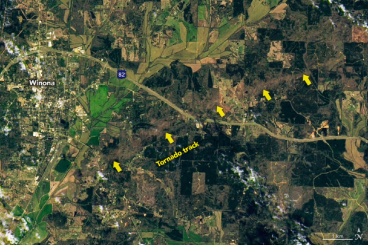
NASA Earth Observatory shared a rather grim image of the path of that EF3 tornado, which was captured by the Operational Land Imager-2 (OLI) on the Landsat 9 satellite Saturday, the day after the tornadoes hit the region.
Much of the tornado's track, which is indicated by yellow arrows, is visible in the satellite image, according to NASA Earth Observatory. It shows just how massive the devastation of the tornado was.

It's even more apparent in the more detailed image of the area through Winona, where the tornado track can clearly be seen across the landscape.
Some tornadoes are so violent that they end up scarring the landscape, making them visible from space, the NASA Earth Observatory noted. These images only show a little bit of the scope of the tornado events. The stronger EF4 tornado was out of the view of the Landsat 9 satellite. The National Weather Service listed 20 reports of tornadoes in Mississippi and Alabama last Friday.
Videos shared by the Mississippi Emergency Management Agency (MSEMA) showed the devastation caused by the tornadoes.
Here is a look at some of the tornado damage in Carroll County, Mississippi from the storm on March 24, 2023. This video was recorded on 3/25/2023.
— msema (@MSEMA) March 27, 2023
For information on how to help go here:https://t.co/CA5kEfs2UV
Feel free to use it for broadcasting, please credit @MSEMA pic.twitter.com/T5vhSYcbT8
The MSEMA confirmed 21 storm-related fatalities, 13 of them in Sharkey County, as of Monday.
"MEMA is thankful for all the first responders, volunteers, and the outpouring of support from everyone in the state and across the nation," the agency said. "We have a lot of work to do but we will respond, recover, and rebuild together."
MEMA is thankful for all the first responders, volunteers, and the outpouring of support from everyone in the state and across the nation. We have a lot of work to do but we will respond, recover, and rebuild together. pic.twitter.com/Byl0dQDqsX
— msema (@MSEMA) March 27, 2023
It added that those who would like to volunteer should not "self-deploy" and instead, they should coordinate with Volunteer Mississippi.

© Copyright IBTimes 2024. All rights reserved.
-

Self-care: Orangutan Seen Apparently Treating Wound
-

European Court Upholds Italy's Claim To Greek Bronze In US Museum
-

Colombian School, A Grim Reminder Of Atrocities Of Rubber Fever
-

More War Debris In Gaza Than Ukraine: UN
-

UK Confirms First Migrants Held For Rwanda Deportation Flights
-

Tesla To Cut Hundreds More Jobs In Musk Cost Push: Report
-

Microsoft Is Turning Into The 'Maestro' Of AI Transformation
-

US-Japan-Philippines Alliance: A Trio With Bitter Past Now Threatens China's Maritime Ambitions
-

Abu Dhabi-backed Group Ends Telegraph Takeover Bid
-

New Post-Brexit Controls: A Thorn For UK Horticulture


